- What are the Andes Mountains? The Andes Mountains form the world's longest continental mountain range, stretching over 7,000 kilometers along South America's western edge. They feature towering peaks, active volcanoes, and diverse ecosystems, profoundly influencing climate and culture across seven countries.
- Where is the Amazon River Basin? The Amazon River Basin, a vast lowland region, encompasses approximately 7.05 million square kilometers across nine South American countries. Centered around the mighty Amazon River, it is home to the world's largest rainforest and unparalleled biodiversity, crucial for global environmental health.
- What defines the Atacama Desert? The Atacama Desert, primarily located in northern Chile, is famously one of the driest non-polar deserts on Earth. Its extreme aridity is due to a rain shadow effect and the cold Humboldt Current, resulting in unique geological formations and specialized flora and fauna.
- Which islands form the Caribbean? The Caribbean consists of thousands of islands, islets, reefs, and cays forming an archipelago. Major groupings include the Greater Antilles (Cuba, Hispaniola, Jamaica, Puerto Rico) and the Lesser Antilles, known for their stunning beaches, coral reefs, and volcanic origins.
- What unique features does Patagonia have? Patagonia, shared by Argentina and Chile, is characterized by its dramatic landscapes. It boasts vast steppes, majestic glaciers like Perito Moreno, rugged mountains including Fitz Roy, and an extensive coastline, making it a unique frontier of natural beauty and extreme weather.
- How do climate zones vary across Latin America? Latin America experiences a wide spectrum of climate zones, from tropical rainforests near the Equator (Amazon) to arid deserts (Atacama) and temperate regions (Pampas, Patagonia). High altitude areas like the Andes also create distinct alpine climates, showcasing extreme variation within short distances.
- Why is Latin America's geography so diverse? Latin America's extreme geographical diversity stems from its vast latitudinal extent, active tectonic plate boundaries (creating the Andes), and significant oceanic currents. These factors interact to produce an incredible array of landscapes, ecosystems, and microclimates across the entire continent.
Uncover the breathtaking physical features of Latin America with this comprehensive 2026 guide. From the majestic Andes Mountains carving the continent's western edge to the unparalleled biodiversity of the Amazon River Basin, this region presents a tapestry of natural wonders. Discover how diverse landscapes, including the arid Atacama Desert and the vibrant Caribbean Islands, profoundly influence local cultures, ecosystems, and travel experiences. This content provides essential navigational and informational insights, helping you understand the geological forces that shaped this dynamic landmass. Engage with detailed descriptions of major landforms, climate zones, and significant waterways, ensuring you possess a deeper appreciation for Latin America's unique geographical identity. Prepare to explore a world where ancient geological processes continually shape modern realities, offering endless opportunities for discovery and learning.
Questions & answers
What are the main mountain ranges in Latin America?
The dominant mountain range in Latin America is the <strong>Andes Mountains</strong>, stretching along the western coast of South America. Other significant ranges include the Sierra Madre Occidental and Oriental in Mexico, and various smaller ranges throughout Central America, all influencing regional climates and ecosystems profoundly.
Where is the Amazon River and its basin located on the map?
The <strong>Amazon River</strong> and its immense basin are predominantly located in northern South America, primarily within Brazil, Peru, and Ecuador. This vast system extends into Colombia, Venezuela, Bolivia, Guyana, Suriname, and French Guiana, encompassing the world's largest rainforest and hydrological network.
What is the driest desert in Latin America and where can I find it?
The driest non-polar desert in Latin America, and globally, is the <strong>Atacama Desert</strong>. It is primarily situated in northern Chile, extending into parts of Peru, Bolivia, and Argentina. Its extreme aridity results from a unique combination of geographic and climatic factors.
How do physical features influence Latin America's climate zones?
Physical features profoundly shape Latin America's climate. The towering <strong>Andes Mountains</strong> create rain shadows and altitudinal zones, while the vast <strong>Amazon Basin</strong> fosters a humid tropical climate. Oceanic currents and latitudinal expanse further contribute to the continent's wide array of climate zones, from desert to alpine.
What are the key characteristics of the Caribbean Sea and its islands?
The <strong>Caribbean Sea</strong> is characterized by its tropical climate, warm clear waters, and extensive coral reefs. Its islands, a mix of volcanic and coral formations, are renowned for their biodiversity and natural beauty. These features attract significant tourism and support unique marine ecosystems.
Which significant plains and grasslands are found in Latin America?
Latin America features several significant plains and grasslands. The most prominent are the <strong>Pampas</strong>, fertile lowlands in Argentina, Uruguay, and southern Brazil, ideal for agriculture. Other notable regions include the Llanos, savannas in Venezuela and Colombia, and the Gran Chaco, a hot, dry plain in central South America.
Welcome to your essential guide to Latin America's stunning physical features. This vast and vibrant continent, a beacon of natural diversity, holds secrets waiting to be uncovered through its unique geography. From towering mountain ranges to expansive river systems and arid deserts, understanding these features isn't just about geography; it's about grasping the very essence of the region's cultures, climates, and breathtaking landscapes. Whether you're planning a future adventure in 2026 or simply curious about the Earth's grand designs, a clear grasp of Latin America's physical map will enrich your perspective. Let's navigate this incredible terrain together, discovering the natural marvels that shape this captivating part of the world.
Latin America's physical geography is a testament to powerful tectonic forces and millennia of natural evolution. This region boasts an incredible array of ecosystems, influencing everything from local agriculture to global weather patterns. Delving into its diverse landforms, from the colossal Andes, the world's longest continental mountain range, to the sprawling Amazon, the planet's largest rainforest and river system by discharge volume, offers unparalleled insights. Each feature plays a critical role in the region's ecological balance and human development. This guide will help you visualize these significant geographical elements, offering a deeper understanding of their impact and allure for travelers and explorers alike.
Frequently Asked Questions
Where are the major physical features found on a Latin America map?
The major physical features span Latin America, from the towering Andes Mountains along the west coast to the immense Amazon River Basin covering much of the continent's interior. You will also find the Patagonian plains in the south and the diverse Caribbean Islands to the north, offering truly varied landscapes.
How can Local MAPs help me navigate Latin America's diverse terrain?
Your mobile Maps app is crucial for Latin America exploration. It provides real-time routes, identifies mountain passes, and locates hidden gems. Download offline maps for remote areas to ensure seamless navigation, enhancing your travel experience significantly.
What are the best times to experience Latin America's unique landscapes?
Optimal travel times vary by region. For the Andes, visit during the dry season, typically May-September. The Amazon is best explored July-December. Enjoy Caribbean coasts December-May, avoiding hurricane season for ideal conditions.
Quick Guide to Key Latin American Features
- Andes Mountains Western spine of South America, highest peaks.
- Amazon River Basin Sprawling rainforest, immense biodiversity.
- Atacama Desert Driest non-polar desert, northern Chile.
- Patagonia Southern Argentina and Chile, glaciers, plains.
- Caribbean Sea Archipelago of islands, coral reefs.
- Pampas Fertile lowlands of Argentina, Uruguay, Brazil.
Understanding the interplay of these features, from the dramatic geological formations to the life-sustaining river systems, is crucial for anyone exploring Latin America. This geographical mosaic profoundly impacts climate, vegetation, and human habitation, creating a rich tapestry of experiences. The vibrant ecosystems supported by these features contribute significantly to global biodiversity, making them vital areas for conservation and scientific study. Each region tells a unique story of natural history and cultural adaptation, inviting further exploration and appreciation. Prepare to be inspired by the sheer scale and beauty of this continent's natural heritage as you visualize these magnificent landscapes on your map.
Key highlights
Andes Mountains Amazon River Basin Atacama Desert Caribbean Islands Patagonia Pampas Mesoamerican volcanism biodiversity hotspots climate zones Latin America geography
In pictures


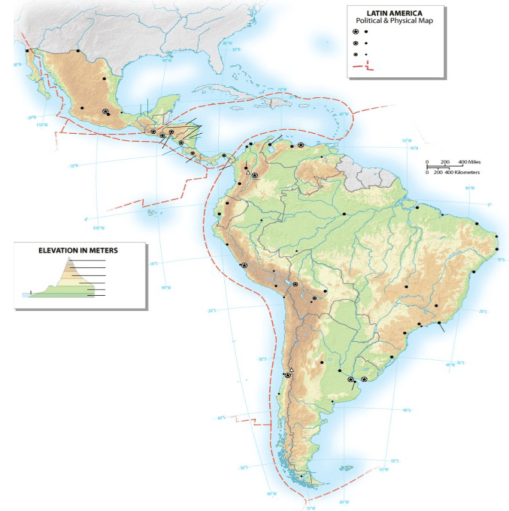
Online Maps Physical Map Of Latin America Geographic Features NHVIWN IMG 9443 WORLD GEO 7089 Landforms 6533958 Orig 6533958 Geography Picsninja Club Class Mrs Aguilar S Social Studies Large Detailed And Hydrographic Quiz PSRKPO4J5GP Moria Nadeau FG04 01LATINAMERICA FG04 01LATINAMERICA Coach Smith LATIN252520AMERICA252520PHYSICAL Teaching Resources E0268EB365CA47568AEB679E42B26DF0 Labelled Diagram 1CB54D42FECB46068377C64D19C33CBA.

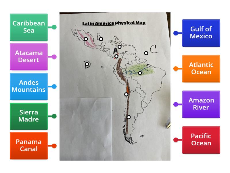
Latin America Physical Map Quiz Geography Diagram Quizlet HNKD5WOSCYJU6UTKGBP3JQ B HNKD5WOSCYJU6UTKGBP3JQ Features Labelled 44d5fbdd62e84160a5d436c4323cd117 Set Clipart By Helpful Hitts Original 13177318 Match Up 96D49622760C4485BADAD1575AD948FD American C5C4CFC1DE3343EFA25D4DEDC6186F19 Online Maps Of Iqqw CFPXMT2YT55Z7GJYL W15D8IZXPSU4NFCZ SX4J5 R5EY6Y 5LEZHA34IBD8ADFJQK1DCRA ZF8V3 N22EVHBVELFL RQBQK8BGCZEBDNTFEFOHMFL4FXMWKAHRW1200 H630 P K No Nu CFPXMT2YT55Z7GJYL W15D8IZXPSU4NFCZ SX4J5 R5EY6Y 5LEZHA34IBD8ADFJQK1DCRA ZF8V3 N22EVHBVELFL RQBQK8BGCZEBDNTFEFOHMFL4FXMWKAHRW1200 H630 Bundle Driver S Education Guru 3970254 URX5RT5XYC9 DQQZ5O4RYHOV5QQL6O2QBG DQQZ5O4RYHOV5QQL6O2QBG TPT Large 13752022 V7UQGRHAOS YFAKVHQQ4JW V7UQGRHAOS YFAKVHQQ4JW Clip Art For Teachers PNG Il 794XN 6753409459 IIO5 794XN 6753409459 IIO5.


Physical Features Of Latin America Pptx 2048 Map Answer Key Verified Academic Solutions La Fill In 2048 With Printable Labeled All For One IMG 0297 Labelled Diagram 4a2dd048f67c45feb4a38764c90df516 Geography Political Standards Image Teaching Resources 1420E7D61C4148DEB1D19588386D743F Slides Assignment Review Quiz TPT 750F 6702480 750F 6702480 Geographic Physicalsouthamerica Science Common Core RH Graphic Organizers Original 8589073.